


2023 08 - Lasso col de Plan Bois

Chabard
User
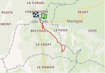

Length
9.8 km

Max alt
1302 m

Uphill gradient
700 m
Km-Effort
19.1 km

Min alt
694 m

Downhill gradient
682 m
Boucle
Yes
Creation date :
2023-09-04 08:43:46.0
Updated on :
2023-09-04 11:40:29.595
2h56
Difficulty : Medium

FREE GPS app for hiking
 SityTrail
IGN / Geographical institutes
SityTrail Plus
The world is yours!
About
Trail Walking of 9.8 km to be discovered at Auvergne-Rhône-Alpes, Upper Savoy, Les Clefs. This trail is proposed by Chabard.
Description
Lasso col de Plan Bois
Positioning
Country:
France
Region :
Auvergne-Rhône-Alpes
Department/Province :
Upper Savoy
Municipality :
Les Clefs
Location:
Unknown
Start:(Dec)
Start:(UTM)
292649 ; 5081933 (32T) N.
Comments